
Home > TC & Geodetical Point
In addition to the
(possibly Roman) structures near the megalith, later
attention given to the site of Monte da Igreja is also documented by two
surveying points erected close to the megalith. There are two such structures:
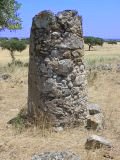
| (1) A derelict
Geodetical Point ("Anta 2" on the 1:50,000 land register map),
approximately 2m high and with a direct visual connection to Évora
at 10km distance to the Northeast and Torre de Coelheiros at a similar distance
to the South.
This stone tower may be as old as the mid 19th century. |
|
||
|
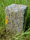
(2) A small marker
from a 20th (?) century land register survey of the area bearing an inscription
reading "TC 654" (TC = triangulação cadastral). This
point is listed in a document of the Instituto Português de Cartografia
e Cadastro with the following co-ordinates:
M 726,663.78 (distance to meridian) |

Both structures were probably not built here because of the megalith. Instead, like the megalith, they exploit the same topographical location of the small but widely visible hill between Évora and Torre de Coelheiros. Yet the megalith had not suddenly become invisible, so that it must have been noted by those who built and used these surveying points.
Maybe the megalith too was, at some point during its long existence, a structure to be seen from a distance? Maybe the megalith was, at another point during its long 'life', a marker of a particular piece of soil, fixing its precise location permanently onto the memory of the land?
Webdesign © M E Chester-Kadwell 2001