

Home > Geophysical Survey
The geophysical prospection used both magnetometer and electrical resistance-meter measurements. It was carried out by Posselt & Zickgraf Prospektionen GbR in 2000. We surveyed 17,500 m² all around the site with the magnetometer and 4,000 m² fairly close to the site with the resistance-meter.
Although large parts of the magnetometer data show the impact of magnetic bedrock, there is also clear evidence for archaeological features. Most of it is restricted to an area close to the small rectangular building. In addition to the ceramics that was visible on the surface, there appear to be more finds as well as features in the ground. Other anomalies indicate features that would have to be investigated more closely through excavation. Our excavations in 2001 confirmed the suspicion of many ceramics to be found in this area, but we have yet to find interesting features!
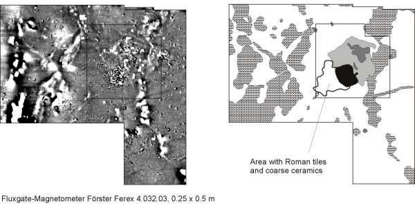
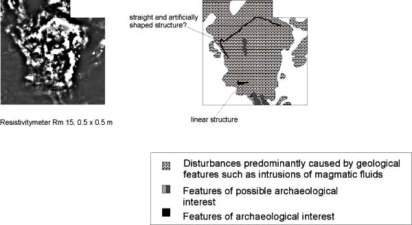
The resistivity survey reveals no clear evidence for anthropogenic structures, but there are some noteworthy anomalies. One small linear structure is situated precisely where the magnetometer survey also indicated an archaeological feature. This may be part of a wall. Elsewhere, the outer limit of a large geological feature looks surprisingly straight and artificially shaped in the way a terrace may have been cut. These and other anomalies of the resistivity data will have to be further evaluated by additional surveying or by excavation.
These images are easier to read when compared with an aerial photograph and the main plan of the site (in roughly the same orientation):
 |
 |
Webdesign © M E Chester-Kadwell 2001